This article by Captain Lance M. Savaria, Head of Projects at Offshore Monitoring Limited, looks into how advancements in maritime connectivity are revolutionizing the shipping industry’s SmartShip technology.
What a difference fast data makes for all ship technology. Many of us can recall that just a few years ago there were limited choices for ship connectivity – technological limitations meant supplying connectivity that was considered enough data through-put ability for telex, fax, voice, and some basic data transfer. Nothing was streamed, periodic data downloads, synchronization, and shared shipboard networks strained the use of ship data operations and crew use and wellbeing. At the time it is often delivered insufficient service to meet basic needs.
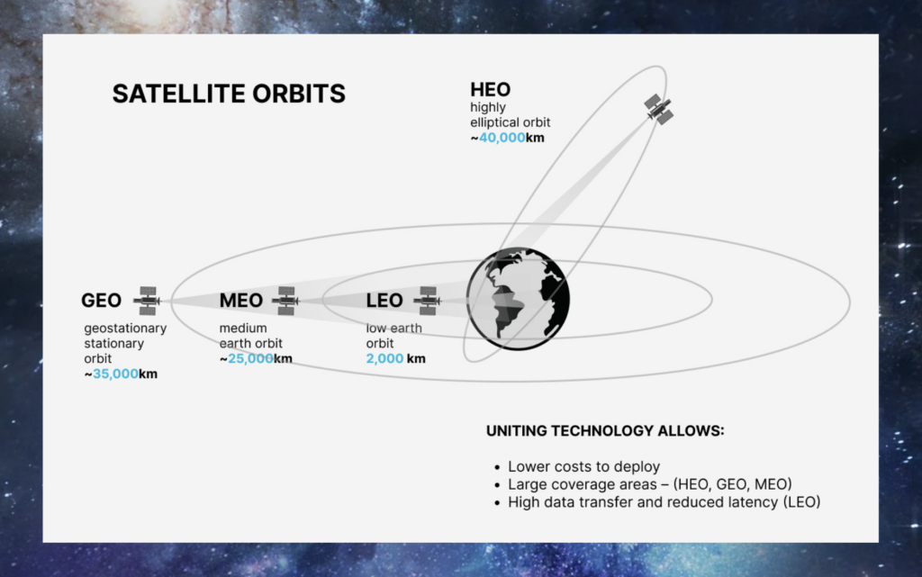
So, let’s look at what has changed. Looking at ship connectivity service broadly it is now based on four distinct networks of satellites in varying geosynchronous orbits, the HEO or high earth orbit at about ~40,000km (about 24854.8 5 mi) , Likewise, there is a GEO – Geosynchronous orbit ~35,000 km (about 21747.99 mi), a MEO – medium earth orbit ~25,000 km (about 15534.28 mi) and a LEO – low geosynchronous orbit ~2,000 km (about 1242.74 mi) with each orbit having its own connectivity capabilities that include connection reliability, data speeds, and acceptable latency (the processing of computer data over a network connection).
What I can see is that it is increasingly competitive and popular to use low geosynchronous orbit to deliver some of the highest speed and low latency connectivity services. Today we can see many industry media posts about how their fleets are considering and are switching to replace or combine their existing connection services to test it out, so far it seems the ongoing results are positive.
This availability of high and low orbit satellite connectivity illustrates that satellite technology is never stagnant and that improved maritime connectivity and global coverage is driving the data dependent systems of a ’SmartShip‘. Not only for the ship data dependent operations and “The Internet of Things’ (IoT) that includes sensors checking mechanical and digital devices, delivering details like fuel consumption, voyage optimization, but also for the crew well-being, training, and safety of operations.

So why am I speaking so much about maritime connectivity? It is because the shipping industry within the most recent five years is undergoing a very rapid and exponential adoption of data dependent ’SmartShip technology’. It is a technological transformation with a high adoption rate by ship owners and operators because it qualifies the investment through forward-looking commercial benefits. The benefits are in the adoption of automation, IoT sensors, and engineering remote monitoring and servicing, and data analytics which improve efficiency, reduce costs, and enhance safety.
Commercially it is often labeled as part of ‘SmartShip’ technology. Validated by industry through its ongoing rapid adoption and investment in high-speed connectivity services, it is the primary driver and enabler of ‘Smart Ship’ technology. Improvement in its reliability, service coverage, and affordability all the while creating confidence that high speed and low latency connectivity will support the connectivity demands of future SmartShip technologies.
One area of ‘SmartShip’ technology, that is growing in importance, is the adoption of high-definition sensors paired with Artificial Intelligence (AI). SmartShips are adopting high precision navigation technology to use effectively, reliably, and safely. It is in a way a path to ‘earn the trust’ of the industry by showing its ability over and over until there is sufficient data to make the assurances needed before adoption. Will this take years? Perhaps, yes, but all agree SmartShip, and autonomous AI-aided navigation is the eventual goal. It is not whether SmartShip autonomous navigation will be a reality but rather when it will be a reality.

Let us look at one ‘SmartShip’ technology that is gaining notoriety and importance. It has its roots in the industry-wide technology drive to develop a completely autonomous ship. Yet it could be considered an interim stage or phase of navigational technology.
An interesting example of the adaption of navigational safety and autonomous technology that I refer to as ‘near proximity’ navigation aid systems are the use of multi sensors mounted for an unobstructed scanning area, enabling real-time, highly correct object detection and object, wildlife, or semi submerged hazard identification. I am referring to the surface water and the upper water column near proximity to the ship, for example from a few meters’ outward to several kilometers/nautical miles. An example of this technology was introduced recently by a UK based company ‘Ladar Ltd.’ with their Ladar TM Sensor Suite.

That is not the end of the capability as the captured sensor-based data is augmented by artificial intelligence and machine learning creating a visual situational assessment – a much improved navigational tool for swift and correct decision-making. Multiple inputs from three Sensors: Visual, Thermal & Lidar through both cameras results in detection, characterization, classification and tracking of distinct types of objects such as vessels, small crafts, debris, floating containers, fishing gear (plastic), ice floes, mammals, and others. It uses AI to fuse data aggregation systems into a comprehensive object detection system with a user-friendly GUI (graphical user interface) for mariners. The system can be connected to a decision support system (DSS) for Maritime Autonomous Surface Ships (MASS) Level 1 and beyond. In conclusion, the advancements in satellite – global coverage and high broadband data connectivity have enabled the rapid adoption of many SmartShip technologies within maritime. The development of high and low orbit satellite-based internet services has transformed the way ships are connected to the internet, supplying high-speed and low-latency connectivity that can support the current and future demands of IoT systems and data transmission. This connectivity improvement is the primary driver and enabler of SmartShip technology, enabling the adoption of automation, IoT sensors, engineering remote monitoring and servicing, and data analytics that improve efficiency, reduce costs, and enhance safety.
As the shipping industry continues to embrace SmartShip technology, it is becoming increasingly clear that the future of navigation safety lies in autonomous AI-aided navigation. While it may take years to fully realize this goal, the adoption of improved navigational safety-related technology, such as the near proximity detection system, is a step towards achieving this vision. Overall, the advancements in maritime connectivity are transforming the shipping industry, paving the way for a more efficient, safe, and sustainable future. A key point to remember is how the adoption of improved navigational safety technology paired with Artificial Intelligence (AI) is growing in importance. The advancements in satellite technology are transforming the shipping industry and paving the way for a more efficient, safe, and sustainable future.